Why East Asia Has Such a High Proportion of Mountainous Land
Overview of East Asia’s Mountainous Terrain
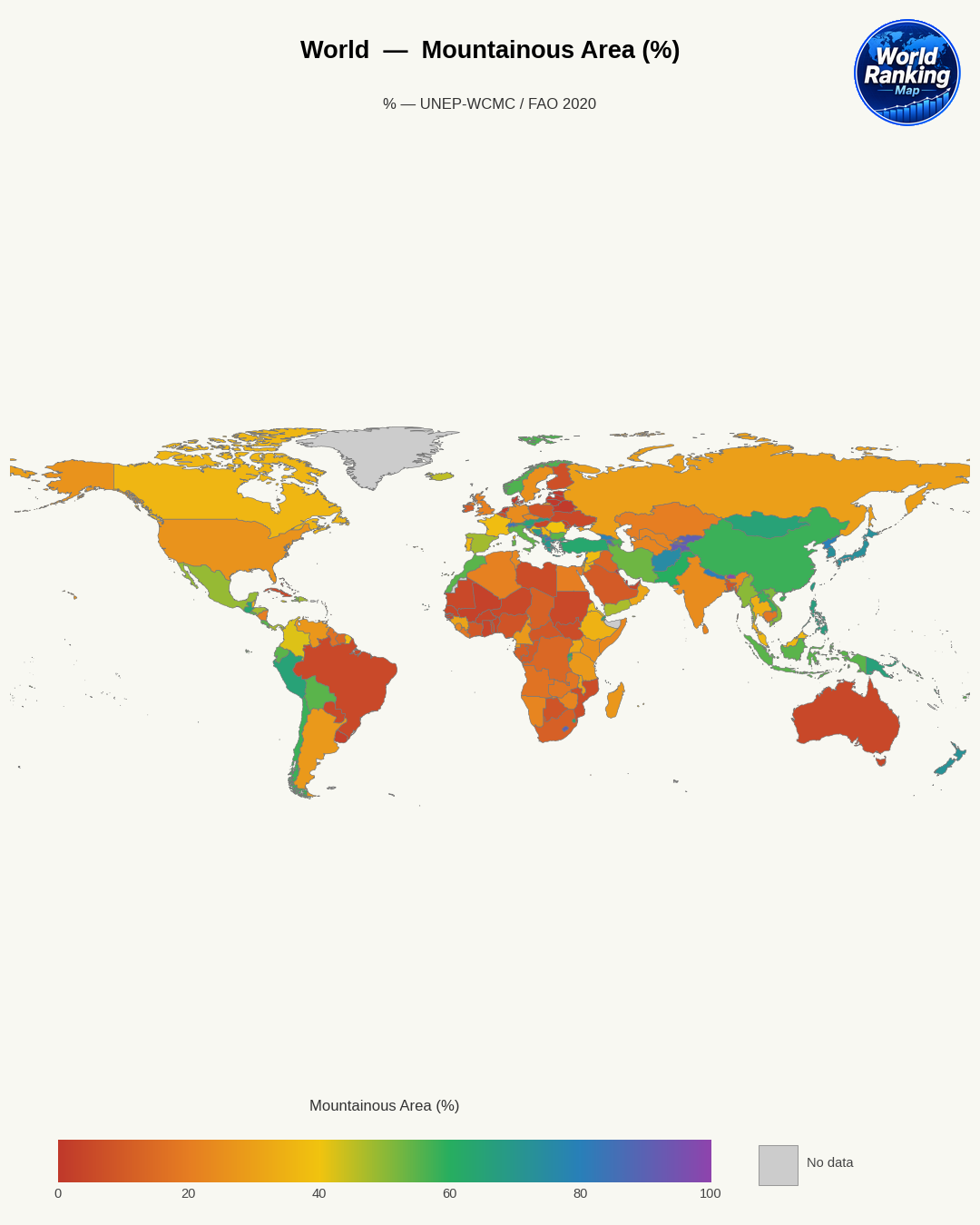
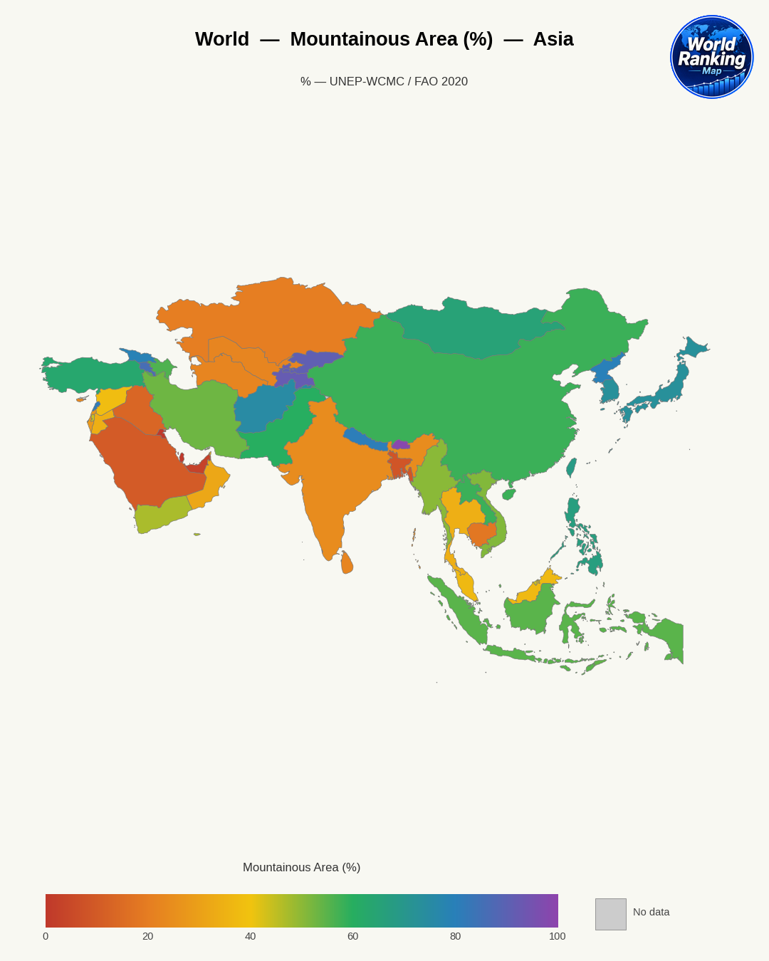
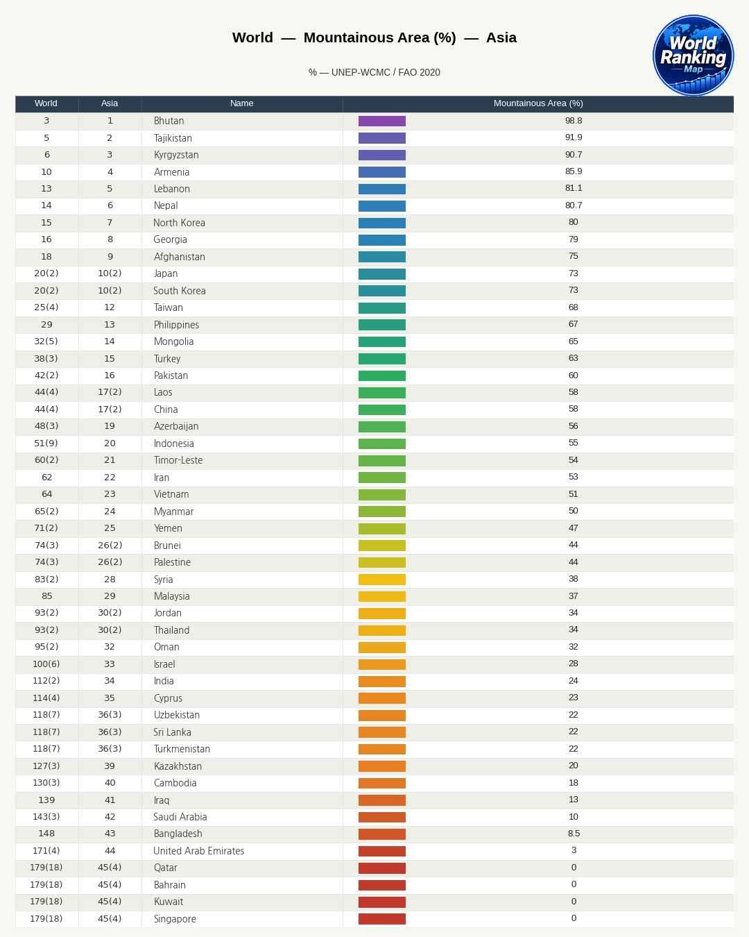
East Asia is widely regarded as a region with an exceptionally large expanse of mountainous land. From the plateaus and mountain ranges of western and southwestern China, to the mountainous terrain of the Korean Peninsula, the rugged landscapes of the Japanese archipelago, and the steep mountain ranges of Taiwan, mountains and hills occupy a larger share than plains in many areas. In particular, Japan and Korea have substantial portions of their territory made up of mountainous land, and China, despite its eastern plains, also has a very large overall share of plateaus, basins, and mountain ranges.
The central question of this article is simple: Why does East Asia have so much mountainous terrain? The answer is not merely that “mountains have been there for a long time,” but rather that it is the result of plate tectonic collisions, large-scale uplift, volcanic activity, and erosion and river action working together over a long period. In other words, East Asia’s mountainous landscapes are the product of both the Earth’s internal forces, which are still active today, and external processes that wear down the surface.
The Influence of Plate Tectonics and Crustal Movement
The most fundamental reason East Asia has such a high proportion of mountainous land lies in its complex plate-boundary environment. This region is broadly affected by the Eurasian Plate, the Pacific Plate, and the Philippine Sea Plate, with the effects of the Indian Plate’s collision also extending from the south. As multiple plates push against one another, subduct, and twist, the crust has been unable to remain stable, and as a result mountain ranges and highlands have formed extensively.
The Pacific Plate and the Philippine Sea Plate tend to subduct beneath the Eurasian Plate along East Asia’s margins. In such subduction zones, earthquakes and volcanic activity are frequent, and compression of the crust makes mountain formation more likely. The Japanese archipelago, the Ryukyu Islands, and the area around Taiwan are especially strongly affected by this structural setting.
Even the interior of the Chinese mainland is not a completely stable, flat landscape. Compression and deformation have been transmitted into areas somewhat removed from the direct plate boundary, causing widespread uplift and fault movement. As a result, East Asia developed not just a few coastal mountain ranges, but a three-dimensional landscape in which plateaus, basins, and mountain ranges are continuously linked across the continent.
The Ripple Effects of the Himalayas and the Tibetan Plateau
One event that cannot be overlooked when understanding East Asia’s topography is the collision between the Indian Plate and the Eurasian Plate. This collision is famous for creating the Himalayas and the Tibetan Plateau, but its effects did not remain confined to that region. The enormous collision energy was transmitted widely into the interior of the Eurasian continent, becoming an important backdrop for crustal deformation and uplift across East Asia.
The Tibetan Plateau is one of the highest and largest plateaus in the world, and it serves as a massive geographic core in its own right. Its formation had a major impact on the development of mountain ranges, basin formation, and changes in river flow in western and southwestern China. The complex mountainous terrain and deep valleys of Yunnan and Sichuan are also closely tied to this large-scale uplift.
In addition, the uplift associated with the Himalaya-Tibet system has influenced East Asia’s climate and erosion systems. High terrain alters monsoon patterns and precipitation distribution, and it promotes strong erosion and river incision. In other words, the collision between the Indian Plate and the Eurasian Plate did not merely create ultra-high mountains in the southwest; it was an event that strengthened the conditions for mountain development across all of East Asia.
Volcanic Activity and the Mountainous Landscapes of Island Regions
The places where mountainous terrain stands out most in East Asia are island regions such as Japan and Taiwan. These areas are where subduction and orogenic activity are concentrated, making volcanic activity and crustal uplift especially active. As a result, mountains occupy a very large share of the land area, while plains remain relatively limited.
Japan is a classic example. The Japanese archipelago lies along the boundary where several plates meet, so volcanic, seismic, and fault activity are frequent. Not only famous volcanoes like Mount Fuji, but also mountain ranges and volcanic landforms spread across the archipelago occupy a large part of the country. Japan’s plains are concentrated in a few lowland areas such as the Kanto Plain and the Nobi Plain, and overall mountainous terrain is far more dominant.
Taiwan is similar. A high mountain range runs north to south through the island’s central region, and coastal plains and alpine terrain change abruptly over a short distance. This shows that active uplift and erosion are occurring at the same time.
- Subduction zones promote volcanic activity and mountain building.
- Island-arc terrain tends to create narrow, elongated mountainous archipelagos.
- Continuous uplift creates conditions more favorable to mountain formation than to flattening.
In this way, East Asia’s island countries have so much mountainous terrain not simply because they are islands, but because they sit on active plate boundaries.
Complex Terrain Shaped by Erosion, Uplift, and River Development
Mountains do not remain unchanged once they form. East Asia’s mountainous landscapes have become even more complex through the repeated interaction of uplift and erosion over long periods of time. When tectonic forces raise the land, rain, snow, wind, and rivers wear it down. When these two processes continue simultaneously, deep valleys and rugged mountains are more likely to develop than broad, gentle plateaus.
East Asia is strongly influenced by the monsoon, and many areas receive abundant precipitation, so river erosion is highly active. In southern China, the Korean Peninsula, Japan, and Taiwan, many mountain areas have been deeply cut by rivers, creating sharp contrasts between ridges and valleys. The upper reaches of the Yangtze, Yellow, and Mekong Rivers are representative examples of this long-term incision.
Fault movement also creates stepped terrain or basins, and rivers flow along those gaps, further subdividing the landscape. As a result, East Asia’s mountains developed into a complex terrain in which mountain ranges, plateaus, basins, and gorges are tightly interwoven.
Why Plains Are Relatively Limited
East Asia does have plains, but overall the share of large, continuous lowlands is limited. The reason is that the crust has continued to uplift and deform, making it difficult for broad areas to remain stably flattened over long periods. In an environment where mountains are repeatedly formed and then eroded, it is hard for vast plains to persist.
In addition, because the coastline is complex and there are many islands and peninsulas, plains that do form usually appear locally in coastal lowlands, lower river reaches, or interior basins. The western coastal plains of Korea, Japan’s Kanto Plain, and China’s North China Plain and the middle-lower Yangtze Plain are important exceptions, but even these plains developed between mountainous areas or where river deposition was concentrated.
To summarize the distribution of plains in East Asia:
- Alluvial plains in major river basins: such as the North China Plain and the middle-lower Yangtze Plain
- Coastal lowlands and deltas: areas where river sediments accumulated
- Basins between mountain ranges: relatively flat interior lowlands such as the Sichuan Basin
- Narrow coastal plains: common in parts of Japan, Taiwan, and the Korean Peninsula
In other words, the scarcity of plains is not simply a matter of area. It is because the geological structure and the process of landform development themselves have been mountain-centered.
How Mountainous Terrain Has Shaped East Asian Society and Economy
A landscape with many mountains has deeply influenced East Asia’s social and economic structure as well. First, settlement and agriculture have concentrated in relatively flat, water-rich areas. As a result, major cities and densely populated regions have generally developed in plains, basins, lower river valleys, and coastal lowlands. Examples include the North China Plain around Beijing, the Yangtze River Delta around Shanghai, the Han River basin where Seoul is located, and the Kanto Plain where Tokyo sits.
By contrast, mountainous terrain has placed major constraints on transportation and infrastructure construction. The cost of building railways, roads, tunnels, and bridges rises, and movement between regions becomes more difficult. For this reason, many East Asian countries have tended to concentrate economic activity along coastal corridors or river corridors.
The impact on agriculture has also been significant. Because the plains suitable for large-scale mechanized farming are limited, some areas developed terraced cultivation or intensive agriculture. Mountainous regions also offer advantages such as forests, minerals, water resources, and hydropower, but they also increase the risk of disasters such as landslides, earthquakes, volcanic eruptions, and floods.
Ultimately, East Asia’s high proportion of mountainous land is not just a feature of the natural landscape. It has been a key condition that has shaped population distribution, urban growth, industrial location, transportation networks, and disaster response strategies. Even today, East Asia’s economic centers remain concentrated in limited plains and coastal areas, while mountainous regions continue to serve as important spaces for ecological conservation, tourism, and water-resource management.